
|
|
 |
|
A Guide for Instruction
 The student lessons, called “Clues”, contain a series of activities and readings that provide a thorough overview of the existing knowledge about the Hopewell culture. To add interest, animated characters named “Danny” the detective and his assistant Debbie provide narration to some of the sections and leads students through steps to solve the Big Question: How did the geography and natural resources of Michigan influence the development of the Hopewell culture? Each lesson is framed as a “Clue” with a key question that they should be able to answer at the end of the lesson. Students can hear Danny talk if the volume is turned up on their computers. When Danny talks, a "Read Along" button will be visible so that it can be read, if they roll their mouse over it. The student lessons, called “Clues”, contain a series of activities and readings that provide a thorough overview of the existing knowledge about the Hopewell culture. To add interest, animated characters named “Danny” the detective and his assistant Debbie provide narration to some of the sections and leads students through steps to solve the Big Question: How did the geography and natural resources of Michigan influence the development of the Hopewell culture? Each lesson is framed as a “Clue” with a key question that they should be able to answer at the end of the lesson. Students can hear Danny talk if the volume is turned up on their computers. When Danny talks, a "Read Along" button will be visible so that it can be read, if they roll their mouse over it.
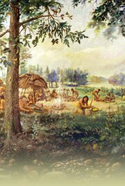
Clue One: Who Were the Hopewell?
This short history of the Hopewell culture can be shown to the entire class as a projection from the internet using your computer. The narrator, Danny, provides a brief introduction which is vocalized. Students can take turns reading the text as it appears on screen. Vocabulary words will appear in blue within the text. Make sure each highlighted word is clicked on to see the definition of the word. A class discussion should be conducted as various points are brought up in the reading. The text with images can also be printed out and distributed to each student. Another alternative is that students can review the lesson independently on line during their computer lab sessions.
Activities
Two timeline activities are provided. These must be printed out before class:
- Activity 1-a asks students to color on a graph the time span eras that each prehistoric people lived.
- Activity 1-b asks students to place a dot on the timeline to show that they know when the Hopewell lived.
Materials
Clue Two: What are Mounds and Why Were They Built?
This short overview covers what a burial mound is and why they were created and can be shown to the entire class as a projection from the internet using your computer. The narrator, Danny, provides a brief introduction which is vocalized. Students can take turns reading the text. Make sure each highlighted word is clicked on to see the definition of the word. A class discussion should be conducted as various points are brought up in the reading. The text can also be printed out and distributed to each student, or students can review the text independently on line during their computer lab sessions.
Activities
- Activity 2-a “Modeling a Hopewell Mound” may be done as a small groups activity or as an individual project.
Materials
Clue Three: How Did the Geography of Michigan Affect the Hopewell?
This is a map reading lesson accompanied by Danny's vocalized narration and can be shown to the entire class as a projection from the internet using your computer. It contains a short, vocalized description of Hopewell life. This lesson contains three maps. The first map relates to rivers and how the Hopewell used rivers for trade. The second and third maps relates to rainfall and suitable land for Hopewell farming. The fourth map relates to climate. Maps depicting Michigan’s geography are used to both identify important features, and as discussion points regarding the Hopewell.
Activities
- Activity 3-a How Do We Use Rivers? This activity asks students to compare how we use rivers today with how the Hopewell used rivers.
-
Activity 3-b The Two Climate Regions of Michigan. This is a verbal activity. Please follow the following dialogue:
- Special Instructions for Activity 3-b: Teacher Dialogue: "Michigan has two climate regions, Humid Continental with warm summers, and Humid Continental with cool summers. Hold your hand up so that it looks like the lower peninsula of Michigan. Find the middle of your smallest finger, and then find the middle of your thumb. Carefully, with the index finger of your other hand, draw a line that connects the two. Basically, that is the way the state is divided into two climate regions."
"Everything north of that imaginary line is in the climate region called Humid Continental Cool Summers. South of that line in Michigan is Humid Continental Warm Summers. Of course that means the entire Upper Peninsula, which is north of your line, would be included in the region Humid Continental Cool Summers"
Let’s discuss:
What makes a region, and who would want to know this information? Now take a moment to complete and label your map.
- Activity 3-c Mapping Michigan’s Rivers This activity asks students to draw and label the main rivers of Michigan using an inset map as a guide.
Materials
Clue Four: How did Michigan’s Natural Resources Affect the Hopewell?
This is a map reading lesson accompanied by Danny's vocalized narration and can be shown to the entire class as a projection from the internet using your computer. It contains a short, vocalized description of Hopewell life. This lesson contains 4 maps. The first map relates to sand and gravel deposits and how the Hopewell preferred to build their mounds on those sites. The second map relates to wildlife available to the Hopewell. The third and fourth maps relates to copper deposits and how copper was used for trading with other tribes for materials to make grave goods. Maps depicting Michigan’s natural resources should be used to both identify important features, and as discussion points regarding how prehistoric people and people today use Michigan’s natural resources.
Activities
- Activity 4-a “Where are Michigan’s Natural Resources?” asks students to answer how some of Michigan’s natural resources were used by the Hopewell and how they are used today.
- Culminating Activity: After completing Activity 4-a, students are asked to write and support an hypothesis of why the natural resources they selected were important to the Hopewell: “Hypothesize: How did the geography and natural resources of Michigan influence the Hopewell culture?”
Materials
return to top
|
|
|
|